1947 Map of Humacao NO
USGS Topo · Published 1947About this map
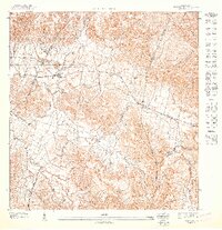
Caribbean National Forest lands dominate the northern and eastern reaches of this mid-century topographic study, where the mountainous terrain of eastern Puerto Rico meets the agricultural lowlands. The central and western portions of the landscape are defined by the winding course of the Rio Gurabo and its numerous tributaries, including Quebrada Honda and Quebrada Arenas. These watercourses supported a rural economy centered on sugar production, evidenced by the presence of Eastern Sugar Associates infrastructure and transportation routes. Small settlements and clusters of dwellings such as Pueblito del Rio, Melillas, and Las Torres are scattered throughout the valleys and lower slopes. The map provides a detailed view of municipal divisions, tracing the boundaries between the Municipio de Juncos, Municipio de Las Piedras, and Municipio de Naguabo.
Find a feature on this map
14 named features on this map. Tap any name to fly to it.
Don’t see what you’re looking for? This feature index may not catch every label — zoom into the map to look around manually.
Map Details
Editions of this 1947 Humacao NO Map
This is the sole edition of this map. No revisions or reprints were ever made.
Historical Maps of Juncos Through Time
Featured Locations
- Las Piedras
- Sector Los Piñeros, Juncos
- Sector Los Castros, Las Piedras
- Sector Los Dávila, Las Piedras
- Brisas del Río, Humacao