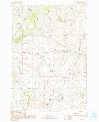
1990 Map of Hunter Mountain
USGS Topo · Published 1991About this map
Ben Dire Mountain and Ben Dire Ridge anchor the landscape of this high-desert region in eastern Oregon, as documented by fieldwork completed in 1987. The terrain is defined by a complex network of seasonal drainages and cattle-country water sources, including the headwaters of Bully Creek and its many tributaries like South Bully Creek and the North Fork Bully Creek. The presence of numerous named springs, such as Schoolmarm Spring, Earp Spring, and Puckett Spring, suggests a landscape managed for ranching and livestock movement through the draws and flats. Managed water storage is evident at sites like the Big Flat Reservoir, Mailbox Canyon Reservoir, and Willow Basin Reservoir, which appear situated to capture runoff from the surrounding peaks. This 1990 provisional map provides a clear record of the area's geography before later development, showing remote landmarks like Steamboat Rock and the high elevation Hunter Mountain Spring.
Find a feature on this map
43 named features on this map. Tap any name to fly to it.
Don’t see what you’re looking for? This feature index may not catch every label — zoom into the map to look around manually.
Map Details
Editions of this 1990 Hunter Mountain Map
This is the sole edition of this map. No revisions or reprints were ever made.
Other maps of this area

1908 · Ironside Mountain
USGS Topo · 1:125,000

1955 · Baker
USGS Topo · 1:250,000

1955 · Burns
USGS Topo · 1:250,000

1955 · Canyon City
USGS Topo · 1:250,000

1955 · Boise
USGS Topo · 1:250,000

1958 · Burns
USGS Topo · 1:250,000

1958 · Boise
USGS Topo · 1:250,000

1959 · Baker
USGS Topo · 1:250,000

1959 · Burns
USGS Topo · 1:250,000

1959 · Canyon City
USGS Topo · 1:250,000