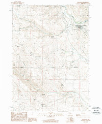
1988 Map of Huntington
USGS Topo · Published 1988About this map
Huntington sits at the northeastern corner of this map, positioned where the Burnt River flows through high desert terrain. The area's transportation and industrial infrastructure are clearly marked, showing the path of the Union Pacific railroad and essential utility corridors. To the south, the landscape is defined by a series of prominent peaks and drainages, including Lost Tom Mountain, Striped Mountain, and Brosman Mountain.
Find a feature on this map
28 named features on this map. Tap any name to fly to it.
Don’t see what you’re looking for? This feature index may not catch every label — zoom into the map to look around manually.
Map Details
Editions of this 1988 Huntington Map
This is the sole edition of this map. No revisions or reprints were ever made.
Other maps of this area

1950 · Jamieson
USGS Topo · 1:62,500

1951 · Moores Hollow
USGS Topo · 1:62,500

1951 · Huntington
USGS Topo · 1:62,500

1952 · Olds Ferry NW
USGS Topo · 1:24,000

1952 · Olds Ferry
USGS Topo · 1:24,000

1952 · Olds Ferry
USGS Topo · 1:62,500

1955 · Baker
USGS Topo · 1:250,000

1959 · Baker
USGS Topo · 1:250,000

1980 · Brogan
USGS Topo · 1:100,000
1988 · Birch Creek Meadow
USGS Topo · 1:24,000