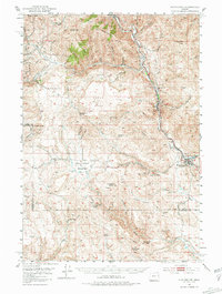
1951 Map of Huntington
USGS Topo · Published 1981About this map
Huntington serves as the primary hub in this portion of the Burnt River canyon, where the Union Pacific rail line follows the winding river corridor alongside the historic Oregon Trail Mon. The map reveals a landscape defined by 19th-century extraction, with numerous Gold Mines and Placer Mines scattered through the gulches north of Weatherby. The transition from the high peaks of Baldy Mtn and Juniper Mtn down to the meadows of Birch Creek Meadows illustrates the diverse terrain that early settlers and miners navigated. The presence of the Pipe Line and the industrial activity at Lime contrast with the earlier ranching and mining patterns of Rye Valley. This 1951 field check preserves the alignment of the Shoestring Grade and the intricate network of water rights evidenced by labels like Watering Trough Dr and Water Trough Gulch.
Find a feature on this map
65 named features on this map. Tap any name to fly to it.
Don’t see what you’re looking for? This feature index may not catch every label — zoom into the map to look around manually.
Map Details
Editions of this 1951 Huntington Map
3 editions found
Other maps of this area

1901 · Baker City
USGS Topo · 1:125,000

1915 · Pine
USGS Topo · 1:125,000

1950 · Jamieson
USGS Topo · 1:62,500

1951 · Moores Hollow
USGS Topo · 1:62,500

1951 · Huntington
USGS Topo · 1:62,500

1952 · Olds Ferry NW
USGS Topo · 1:24,000

1952 · Olds Ferry
USGS Topo · 1:24,000

1952 · Olds Ferry
USGS Topo · 1:62,500

1955 · Baker
USGS Topo · 1:250,000

1957 · Durkee
USGS Topo · 1:62,500