
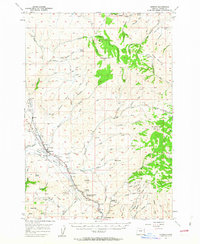
1957 Map of Durkee
USGS Topo · Published 1959About this map
Oregon Trail traces a historic path through the high desert and mountain terrain of Baker County, running parallel to the modern corridor of Highway 30 and the Union Pacific Railroad. The settlement of Durkee serves as a central hub along the Burnt River, while smaller locales like Weatherby and Nelson mark the transport route as it winds between the heights of Big Lookout Mtn and Baldy Mtn. The landscape is etched with the evidence of early industry and community, from the Gold Ridge Mine and a local Quarry to rural education sites like Plano School and Weatherby School. Water sources such as Black Springs, Mud Spring, and Gold Hill Spring are critical landmarks in this arid environment, often associated with gulches and canyons like Kuykendall Gulch and Timber Canyon that define the drainage patterns of the Burnt River Valley.
Find a feature on this map
48 named features on this map. Tap any name to fly to it.
Don’t see what you’re looking for? This feature index may not catch every label — zoom into the map to look around manually.
Map Details
Editions of this 1957 Durkee Map
2 editions found
Other maps of this area

1901 · Baker City
USGS Topo · 1:125,000

1915 · Pine
USGS Topo · 1:125,000

1951 · Huntington
USGS Topo · 1:62,500

1952 · Olds Ferry NW
USGS Topo · 1:24,000

1952 · Olds Ferry
USGS Topo · 1:62,500

1955 · Baker
USGS Topo · 1:250,000

1957 · Halfway
USGS Topo · 1:62,500

1957 · Sparta
USGS Topo · 1:62,500

1957 · Mineral
USGS Topo · 1:62,500

1959 · Baker
USGS Topo · 1:250,000