1986 Map of Hurricane
USGS Topo · Published 1987About this map
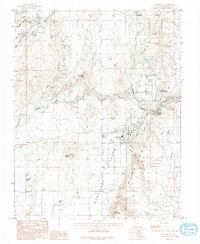
Hurricane sits at the base of the prominent Hurricane Cane escarpment, a landscape shaped by both geological upheaval and irrigation ingenuity in the late 1970s. The Virgin River snakes through the center of the sheet, carving deep canyons as it passes La Verkin and the thermal waters of Pah Tempe Springs. The intricate La Verkin Canal traces the contours above the river, a vital lifeline for agricultural development in this arid region.
Find a feature on this map
45 named features on this map. Tap any name to fly to it.
Don’t see what you’re looking for? This feature index may not catch every label — zoom into the map to look around manually.
Map Details
Editions of this 1986 Hurricane Map
This is the sole edition of this map. No revisions or reprints were ever made.
Other maps of this area

1885 · St. George
USGS Topo · 1:250,000

1891 · St. George
USGS Topo · 1:250,000

1953 · Cedar City
USGS Topo · 1:250,000

1954 · La Verkin 4 NW
USGS Topo · 1:24,000

1954 · La Verkin 4 SW
USGS Topo · 1:24,000

1954 · La Verkin 3 NW
USGS Topo · 1:24,000

1954 · La Verkin 3 NE
USGS Topo · 1:24,000

1954 · La Verkin 1 SW
USGS Topo · 1:24,000

1954 · La Verkin 3 SE
USGS Topo · 1:24,000

1954 · La Verkin 3 SW
USGS Topo · 1:24,000