
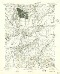
1954 Map of La Verkin 3 NW
USGS Topo · Published 1956About this map
The Virgin River corridor dominates this mid-1950s survey, illustrating the complex geography of Southern Utah where the Dixie National Forest meets early ranching and mining settlements. The community of Harrisburg sits along the foot of White Reef, while Harrisburg Junction marks a key intersection near the water sources of Quail Creek. The map documents a transition in land use, showing both livestock-related features like Bastion Ranch and industrial traces including a Coal Mine and scattered Prospect sites. Evidence of water management for agriculture is clear through the presence of the Ditch near Berry Spring and multiple mountain springs such as Willow Spring and Sand Mountain Spring. Dramatic elevation changes are defined by Black Ridge and the broad expanses of Purgatory Flat and Yant Flat, providing a detailed look at the trail systems and jeep tracks that connected these remote reaches of Washington County.
Find a feature on this map
37 named features on this map. Tap any name to fly to it.
Don’t see what you’re looking for? This feature index may not catch every label — zoom into the map to look around manually.
Map Details
Editions of this 1954 La Verkin 3 NW Map
This is the sole edition of this map. No revisions or reprints were ever made.
Other maps of this area

1885 · St. George
USGS Topo · 1:250,000

1891 · St. George
USGS Topo · 1:250,000

1953 · Cedar City
USGS Topo · 1:250,000

1954 · La Verkin 3 NE
USGS Topo · 1:24,000

1954 · La Verkin 3 SE
USGS Topo · 1:24,000

1954 · La Verkin 3 SW
USGS Topo · 1:24,000

1954 · La Verkin 2 SE
USGS Topo · 1:24,000

1954 · St. George
USGS Topo · 1:62,500

1954 · Hurricane
USGS Topo · 1:62,500
1956 · St. George SE
USGS Topo · 1:24,000