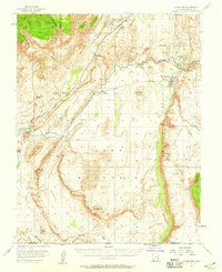
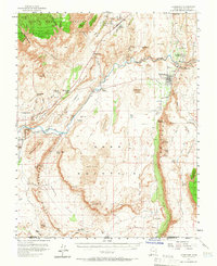
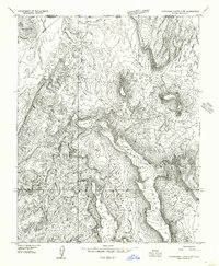
1954 Map of Hurricane
USGS Topo · Published 1959About this map
Leeds and the neighboring settlements of Harrisburg and Toquerville anchor this mid-century look at Washington County's unique desert geography. The map reveals the intricate water management required for the region's agricultural survival, highlighting the Virgin River and its vital tributaries like Quail Creek and Ash Creek, alongside the Gould Reservoir and various irrigation canals. Local industry is evident through the Vanderbilt Mine, several Quarry sites, and the Cinder Pits near the river.
Find a feature on this map
67 named features on this map. Tap any name to fly to it.
Don’t see what you’re looking for? This feature index may not catch every label — zoom into the map to look around manually.
Map Details
Editions of this 1954 Hurricane Map
2 editions found
Other maps of this area

1885 · St. George
USGS Topo · 1:250,000

1886 · Mt. Trumbull
USGS Topo · 1:250,000

1891 · St. George
USGS Topo · 1:250,000

1892 · Mt. Trumbull
USGS Topo · 1:250,000

1953 · Cedar City
USGS Topo · 1:250,000

1953 · Grand Canyon
USGS Topo · 1:250,000

1954 · La Verkin 4 NW
USGS Topo · 1:24,000

1954 · La Verkin 4 SW
USGS Topo · 1:24,000
1954 · Hurricane Cliffs 2 NW
USGS Topo · 1:24,000

1954 · La Verkin 3 NW
USGS Topo · 1:24,000