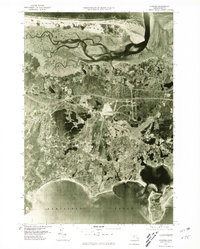
1977 Map of Hyannis
USGS Topo · Published 1981About this map
Barnstable and the surrounding villages of Hyannis and Centerville are captured in high-altitude detail during the late 1970s. This orthophotoquad provides a clear visual record of the mid-Cape's transition, showing the density of residential development and the established road networks of Cape Cod just before the 1980s. The contrast between the developed southern shore along Hyannis Port and the preserved coastal barrier of Sandy Neck to the north is particularly striking.
Find a feature on this map
9 named features on this map. Tap any name to fly to it.
Don’t see what you’re looking for? This feature index may not catch every label — zoom into the map to look around manually.
Map Details
Editions of this 1977 Hyannis Map
This is the sole edition of this map. No revisions or reprints were ever made.
Other maps of this area

1887 · Yarmouth
USGS Topo · 1:62,500

1888 · Barnstable
USGS Topo · 1:62,500

1889 · Yarmouth
USGS Topo · 1:62,500

1893 · Yarmouth
USGS Topo · 1:62,500

1893 · Barnstable
USGS Topo · 1:62,500

1938 · Sandwich
USGS Topo · 1:31,680
1939 · Sandwich
USGS Topo · 1:24,000
1940 · Sandwich
USGS Topo · 1:31,680
1941 · Cotuit
USGS Topo · 1:31,680

1942 · Cape Cod Bay
USGS Topo · 1:125,000