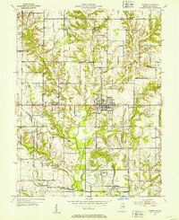
1953 Map of Hymera
USGS Topo · Published 1953About this map
Hymera serves as the industrial and social anchor of this Indiana landscape during the mid-twentieth century, surrounded by an extensive network of active extraction sites labeled Strip Mine. The map reveals a high density of rural institutions that offer significant value for genealogical research, including Nye Chapel, Sugar Grove Ch, and Palmers Prairie Ch. These churches, alongside cemeteries like the Knights of Columbus Cem, are connected by a web of local roads and major rail lines, including the Chicago Milwaukee St Paul and Pacific and the Chicago and Eastern Illinois. To the east, the edge of Shakamak State Park provides a stark contrast to the surrounding coal fields and settlements like Jackson Hill and Miner City. The drainage of Busseron Creek and its many tributaries, such as Sulphur Creek, defines the local topography between these small mining communities and rail stops.
Find a feature on this map
33 named features on this map. Tap any name to fly to it.
Don’t see what you’re looking for? This feature index may not catch every label — zoom into the map to look around manually.
Map Details
Editions of this 1953 Hymera Map
This is the sole edition of this map. No revisions or reprints were ever made.
Other maps of this area

1908 · Clay City
USGS Topo · 1:48,000

1910 · Clay City
USGS Topo · 1:62,500

1940 · Lewis
USGS Topo · 1:24,000

1940 · Linton
USGS Topo · 1:24,000

1940 · Jasonville
USGS Topo · 1:24,000

1940 · Pimento
USGS Topo · 1:24,000

1942 · Shelburn
USGS Topo · 1:24,000

1943 · Hymera
USGS Topo · 1:24,000

1943 · Sullivan
USGS Topo · 1:24,000

1943 · Dugger
USGS Topo · 1:24,000