
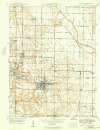
1940 Map of Jasonville
USGS Topo · Published 1940About this map
The industrial and agricultural landscape of Greene, Clay, and Sullivan counties is revealed in this 1938-39 survey. Jasonville and Coalmont serve as the primary hubs, surrounded by an extensive network of Strip Mines that characterize the local economy during this era. The terrain is a mix of active resource extraction and established rural life, evidenced by numerous small community centers such as Howesville and Gilmore. Infrastructure from earlier eras remains visible, notably the Wabash and Erie Canal (Abandoned) which runs near the Eel River.
Find a feature on this map
41 named features on this map. Tap any name to fly to it.
Don’t see what you’re looking for? This feature index may not catch every label — zoom into the map to look around manually.
Map Details
Editions of this 1940 Jasonville Map
2 editions found
Other maps of this area

1908 · Clay City
USGS Topo · 1:48,000

1910 · Clay City
USGS Topo · 1:62,500

1938 · Coal City
USGS Topo · 1:24,000

1938 · Switz City
USGS Topo · 1:24,000

1940 · Lewis
USGS Topo · 1:24,000

1940 · Linton
USGS Topo · 1:24,000

1943 · Hymera
USGS Topo · 1:24,000

1943 · Dugger
USGS Topo · 1:24,000

1947 · Switz City
USGS Topo · 1:24,000

1947 · Linton
USGS Topo · 1:24,000