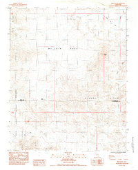
1984 Map of Ibex Pass
USGS Topo · Published 1985About this map
The Old Spanish Trail Highway cuts across the northeastern corner of this desert landscape, tracing a historical corridor of travel near the Amargosa River. This 1980s provisional survey illustrates the transition from the high ridges of the Ibex Hills down toward the southern reaches of Death Valley National Monument. The terrain is marked by significant topographical landmarks such as Tecopa Peak and the critical passage at Ibex Pass, which serves as a natural gateway between the surrounding ranges. Small-scale mining activity is evident through several unnamed mines and prospects scattered near the Mc Lain Park area. The map also delineates the jurisdictional boundary between Inyo County and San Bernardino County, providing a clear view of how these remote desert highlands were organized and surveyed in the late twentieth century.
Find a feature on this map
15 named features on this map. Tap any name to fly to it.
Don’t see what you’re looking for? This feature index may not catch every label — zoom into the map to look around manually.
Map Details
Editions of this 1984 Ibex Pass Map
2 editions found
Other maps of this area

1933 · Avawatz Mountains
USGS Topo · 1:250,000

1947 · Trona
USGS Topo · 1:250,000

1948 · Trona
USGS Topo · 1:250,000

1948 · Avawatz Pass
USGS Topo · 1:62,500

1950 · Tecopa
USGS Topo · 1:62,500

1951 · Avawatz Pass
USGS Topo · 1:62,500

1951 · Tecopa
USGS Topo · 1:62,500

1951 · Shoshone
USGS Topo · 1:62,500

1953 · Trona
USGS Topo · 1:250,000

1956 · Silurian Hills
USGS Topo · 1:62,500