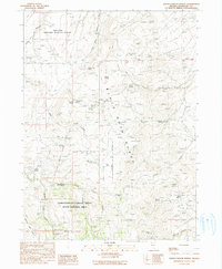
1990 Map of Idaho Canyon Spring
USGS Topo · Published 1990About this map
The Black Rock Range dominates this corner of Humboldt County, defining a landscape of high-elevation springs and deep canyons north of Summit Lake. This 1990 provisional edition, based on earlier surveys and 1980s aerial photography, highlights a region dedicated to conservation and seasonal livestock movement. Large tracts of the Sheldon National Wildlife Refuge and the Lahontan Cutthroat Trout State Natural Area suggest the environmental importance of the local watershed, where Pole Creek and Craine Creek flow through the arid terrain.
Find a feature on this map
35 named features on this map. Tap any name to fly to it.
Don’t see what you’re looking for? This feature index may not catch every label — zoom into the map to look around manually.
Map Details
Editions of this 1990 Idaho Canyon Spring Map
This is the sole edition of this map. No revisions or reprints were ever made.
Other maps of this area

1886 · Disaster
USGS Topo · 1:250,000

1889 · Long Valley
USGS Topo · 1:250,000

1893 · Disaster
USGS Topo · 1:250,000

1954 · Vya
USGS Topo · 1:250,000

1958 · Vya
USGS Topo · 1:250,000

1962 · Vya
USGS Topo · 1:250,000

1965 · Idaho Canyon
USGS Topo · 1:62,500

1965 · Rock Spring Table
USGS Topo · 1:62,500

1972 · Burnt Springs
USGS Topo · 1:24,000
1972 · Red Mountain
USGS Topo · 1:24,000