
Loading...
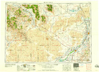
Loading map...1958 Map of Idaho Falls
USGS Topo · Published 1958About this map
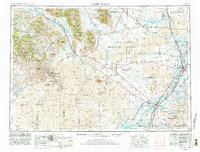
The Snake River corridor anchors this mid-century look at eastern Idaho, where irrigation networks like the Idaho Canal and Aberdeen Canal enabled the growth of Idaho Falls and Blackfoot. This era is defined by the stark contrast between the fertile river valley and the expansive volcanic landscapes of Craters of the Moon National Monument. The map documents a significant industrial and scientific period, notably featuring Atomic City on the lava plains.
Find a feature on this map
160 named features on this map. Tap any name to fly to it.
Don’t see what you’re looking for? This feature index may not catch every label — zoom into the map to look around manually.
Map Details
Date Portrayed1958
Date Published1958
PublisherU.S. Geological Survey
Map TypeTopographic
Scale1:250000
Physical Dimensions29.2 x 22 inches
Editions of this 1958 Idaho Falls Map
2 editions found
Historical Maps of West Idaho Falls Through Time
Featured Locations
Source Details
SourceU.S. Geological Survey
CopyrightPublic Domain