1967 Map of Imperial Beach
USGS Topo · Published 1977About this map
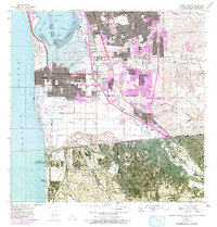
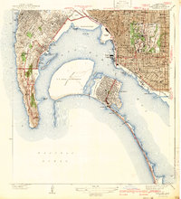
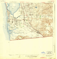
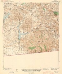
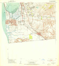
Silver Strand and the southern reaches of San Diego Bay dominate this mid-century coastal landscape, where the international boundary between California and Baja California Norte meets the Pacific Ocean. The map documents a period of rapid urbanization across Chula Vista, Imperial Beach, and San Ysidro, with purple tinting indicating suburban growth extending into former agricultural lands near the Otay River. A heavy military presence is evident through the Us Naval Radio Station and the Imperial Beach Naval Air Station. To the south, the city of Tijuana is depicted with a dense grid, connected to the north via the Mexico Bridge and US Customs Port of Entry. Local institutions like Mt Olivet Cem and the San Ysidro Academy provide anchor points for genealogists and local historians studying the South Bay's development before the late 20th-century expansion.
Find a feature on this map
67 named features on this map. Tap any name to fly to it.
Don’t see what you’re looking for? This feature index may not catch every label — zoom into the map to look around manually.
Map Details
Editions of this 1967 Imperial Beach Map
This is the sole edition of this map. No revisions or reprints were ever made.
Other maps of this area

1903 · Cuyamaca
USGS Topo · 1:125,000

1904 · San Diego
USGS Topo · 1:62,500

1904 · Southern California Sheet No. 2
USGS Topo · 1:250,000

1930 · San Diego
USGS Topo · 1:62,500
1942 · Point Loma
USGS Topo · 1:31,680
1943 · San Ysidro
USGS Topo · 1:31,680
1943 · Jamul
USGS Topo · 1:62,500

1944 · National City
USGS Topo · 1:31,680

1950 · San Diego
USGS Topo · 1:250,000
1953 · San Ysidro
USGS Topo · 1:24,000