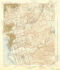
1944 Map of National City
USGS Topo · Published 1944About this map
The coastal plain of San Diego Bay and the rising eastern foothills are captured here during a period of significant military and suburban expansion. Established communities like National City and Chula Vista are shown with their developing street grids, while the interior is dotted with smaller settlements such as Lincoln Acres, Lemon Grove, and Encanto. A striking concentration of memorial sites occupies the center of the sheet, including Mount Hope Cemetery and Greenwood Cemetery, signifying the area's established role as a regional hub for the deceased.
Find a feature on this map
44 named features on this map. Tap any name to fly to it.
Don’t see what you’re looking for? This feature index may not catch every label — zoom into the map to look around manually.
Map Details
Editions of this 1944 National City Map
This is the sole edition of this map. No revisions or reprints were ever made.
Other maps of this area

1893 · El Cajon
USGS Topo · 1:62,500

1901 · Elcajon
USGS Topo · 1:62,500

1903 · Cuyamaca
USGS Topo · 1:125,000

1903 · La Jolla
USGS Topo · 1:62,500

1903 · Elcajon
USGS Topo · 1:62,500

1904 · San Diego
USGS Topo · 1:62,500

1904 · Southern California Sheet No. 2
USGS Topo · 1:250,000

1930 · La Jolla
USGS Topo · 1:62,500

1930 · San Diego
USGS Topo · 1:62,500

1939 · El Cajon
USGS Topo · 1:62,500