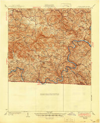
1933 Map of Independence
USGS Topo · Published 1944About this map
Independence sits at the heart of this mountain landscape, serving as a hub for the scattered farming and milling communities of Grayson County during the early 1940s. The area is defined by the winding course of the New River and its junction with the Little River, where numerous river crossings like Rose Ferry and Moore Ferry provided vital transport before modern bridging. The map captures a high density of rural institutions, including Cox Chapel, Maple Shade Ch, and Crab Orchard Sch, reflecting a deeply settled highland culture. Small-scale industry is evident in the survival of local hubs like Brookside Mill and Ohio Mill. To the north, the terrain rises into the Jefferson National Forest, where summits like Comers Rock and Point Lookout Mountain loom over the headwaters of Elk Creek.
Find a feature on this map
96 named features on this map. Tap any name to fly to it.
Don’t see what you’re looking for? This feature index may not catch every label — zoom into the map to look around manually.
Map Details
Editions of this 1933 Independence Map
3 editions found


Other maps of this area

1889 · Hillsville
USGS Topo · 1:125,000

1889 · Wytheville
USGS Topo · 1:125,000

1889 · Wilkesboro
USGS Topo · 1:125,000

1891 · Wilkesboro
USGS Topo · 1:125,000

1891 · Yadkinville
USGS Topo · 1:125,000

1892 · Hillsville
USGS Topo · 1:125,000

1892 · Wytheville
USGS Topo · 1:125,000

1893 · Yadkinville
USGS Topo · 1:125,000

1896 · Hillsville
USGS Topo · 1:125,000

1930 · Speedwell
USGS Topo · 1:62,500