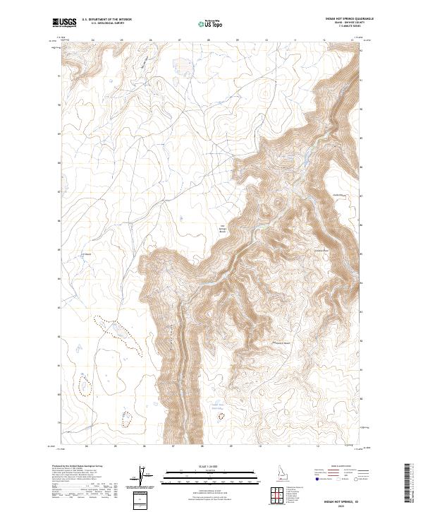
2023 Map of Indian Hot Springs
USGS Topo · Published 2023About this map
Indian Hot Springs marks a vital water source at the confluence of deep canyon systems in this remote Owyhee County landscape. The terrain is defined by the dramatic meeting of the Bruneau River and the Jarbidge River, both of which are protected within the Bruneau-Jarbidge Rivers Wilderness. High plateaus like the Hot Springs Bench and Lookout Point rise above the sheer walls of Bruneau Canyon, overlooking a desert environment segmented into the J-P Desert, Inside Desert, and Diamond A Desert. This 2023 survey illustrates the complex drainage patterns of the high sagebrush steppe, including Cedar Tree Trail Lakes and the seasonal path of Big Lake Draw, highlighting the geological isolation and hydrological importance of the river corridor.
Find a feature on this map
19 named features on this map. Tap any name to fly to it.
Don’t see what you’re looking for? This feature index may not catch every label — zoom into the map to look around manually.
Map Details
Editions of this 2023 Indian Hot Springs Map
This is the sole edition of this map. No revisions or reprints were ever made.
Other maps of this area

1955 · Twin Falls
USGS Topo · 1:250,000

1958 · Twin Falls
USGS Topo · 1:250,000

1978 · The Arch
USGS Topo · 1:24,000
1979 · Antelope Creek
USGS Topo · 1:24,000

1979 · Stiff Tree Draw
USGS Topo · 1:24,000

1979 · Indian Hot Springs
USGS Topo · 1:24,000

1979 · Blackstone Reservoir
USGS Topo · 1:24,000
1979 · Triguero Lake
USGS Topo · 1:24,000

1979 · Cave Draw
USGS Topo · 1:24,000
1979 · Buster Butte
USGS Topo · 1:24,000