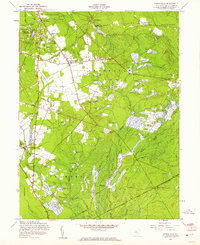
1957 Map of Indian Mills
USGS Topo · Published 1961About this map
Cranberry Bogs dominate this segment of the Pine Barrens, illustrating a landscape defined by intensive wetland agriculture during the mid-20th century. The intricate network of reservoirs and bogs is concentrated around Bozuretown and Oriental, where the drainage of Muskingum Brook and Springers Brook supports these specialized harvests. The map reveals the historical industrial footprint of the region at Hampton Furnace and the legacy of small rural crossroads like Tabernacle and Indian Mills.
Find a feature on this map
35 named features on this map. Tap any name to fly to it.
Don’t see what you’re looking for? This feature index may not catch every label — zoom into the map to look around manually.
Map Details
Editions of this 1957 Indian Mills Map
4 editions found
Other maps of this area

1888 · Pemberton
USGS Topo · 1:62,500

1888 · Mount Holly
USGS Topo · 1:62,500

1890 · Hammonton
USGS Topo · 1:62,500

1890 · Mullica
USGS Topo · 1:62,500

1894 · Hammonton
USGS Topo · 1:62,500

1894 · Pemberton
USGS Topo · 1:62,500

1894 · Mount Holly
USGS Topo · 1:62,500

1894 · Mullica
USGS Topo · 1:62,500

1898 · Pemberton
USGS Topo · 1:62,500

1898 · Mount Holly
USGS Topo · 1:62,500
Featured Places
- Southampton Township, NJ
- Tabernacle Township, NJ
- Shamong Township, NJ
- Meadford Farms, Tabernacle Township
- Oriental, Tabernacle Township