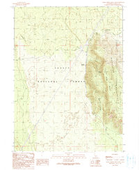
1990 Map of Indian Spring Mountain
USGS Topo · Published 1990About this map
The Whitehorse Mountains dominate the eastern landscape of this 1990 survey, where the rugged terrain meets the level expanse of Julia Glover Flat. This Siskiyou County territory is defined by the overlap of the Shasta National Forest and Modoc National Forest, revealing a remote volcanic and timber-rich environment. Geologic and natural landmarks are prominent, including the Mayfield Ice Cave and several water sources like Mayfield Spring and Indian Spring. Evidence of early 20th-century transportation and industry persists in the form of a Railroad Grade cutting through the forest and a Cinder Pit near Hambone Island, reflecting the area's history of resource extraction and infrastructure development on the high plateau.
Find a feature on this map
14 named features on this map. Tap any name to fly to it.
Don’t see what you’re looking for? This feature index may not catch every label — zoom into the map to look around manually.
Map Details
Editions of this 1990 Indian Spring Mountain Map
This is the sole edition of this map. No revisions or reprints were ever made.
Other maps of this area

1886 · Modoc Lava Bed
USGS Topo · 1:250,000

1892 · Modoc Lava-Bed
USGS Topo · 1:250,000

1932 · Bartle
USGS Topo · 1:96,000

1939 · Bartle
USGS Topo · 1:125,000

1954 · Alturas
USGS Topo · 1:250,000

1958 · Alturas
USGS Topo · 1:250,000

1961 · Hambone
USGS Topo · 1:62,500

1961 · Pondosa
USGS Topo · 1:62,500

1961 · Fall River Mills
USGS Topo · 1:62,500

1962 · Alturas
USGS Topo · 1:250,000