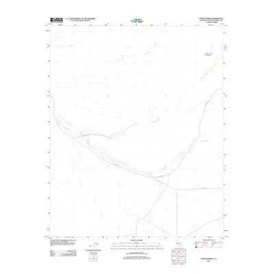
2012 Map of Indian Spring
USGS Topo · Published 2012About this map
Indian Spring and Cane Spring provide rare water sources in this arid stretch of San Bernardino County, where the landscape is defined by vast volcanic and alluvial formations. The presence of the Cinder Cone Lava Beds in the northeastern corner suggests a violent geologic history, while the drainage patterns of Black Tank Wash and Willow Wash dictate the modern navigation of the area. Human activity is centered on a handful of desert routes, most notably Kelbaker Rd and the Aiken Mine Rd. These corridors link isolated markers such as Tank Seven and Tank Six, reflecting the essential infrastructure required for desert travel. The Indian Springs Trl offers a glimpse into historical movement through this terrain, following natural contours between seasonal watercourses like Indian Cr.
Find a feature on this map
11 named features on this map. Tap any name to fly to it.
Don’t see what you’re looking for? This feature index may not catch every label — zoom into the map to look around manually.
Map Details
Editions of this 2012 Indian Spring Map
This is the sole edition of this map. No revisions or reprints were ever made.
Other maps of this area

1910 · Ivanpah
USGS Topo · 1:250,000

1912 · Ivanpah
USGS Topo · 1:250,000

1942 · Ivanpah
USGS Topo · 1:250,000

1947 · Kingman
USGS Topo · 1:250,000

1948 · Kingman
USGS Topo · 1:250,000

1954 · Kingman
USGS Topo · 1:250,000

1955 · Kingman
USGS Topo · 1:250,000
1955 · Mescal Range
USGS Topo · 1:62,500
1955 · Kelso
USGS Topo · 1:62,500
1956 · Halloran Spring
USGS Topo · 1:62,500