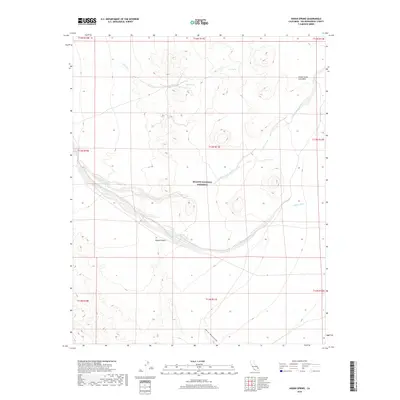
2018 Map of Indian Spring
USGS Topo · Published 2018About this map
The Mojave National Preserve encompasses most of this arid landscape, dominated by significant geologic formations and ephemeral water sources. The Cinder Cone Lava Beds stand out in the northeastern corner, marking an area of ancient volcanic activity within the larger Mojave Desert. Life in this environment centers on precious water points like Indian Spring and Cane Spring, which have long served as vital stops for travelers and wildlife alike. The terrain is defined by dry drainage systems such as Willow Wash, Black Tank Wash, and Indian Cr that carve through the desert floor. To the south, the foothills of the Kelso Mountains begin to rise, creating a transition between the low-lying washes and the higher mountain peaks beyond the quadrangle boundary.
Find a feature on this map
18 named features on this map. Tap any name to fly to it.
Don’t see what you’re looking for? This feature index may not catch every label — zoom into the map to look around manually.
Map Details
Editions of this 2018 Indian Spring Map
This is the sole edition of this map. No revisions or reprints were ever made.
Other maps of this area

1910 · Ivanpah
USGS Topo · 1:250,000

1912 · Ivanpah
USGS Topo · 1:250,000

1942 · Ivanpah
USGS Topo · 1:250,000

1947 · Kingman
USGS Topo · 1:250,000

1948 · Kingman
USGS Topo · 1:250,000

1954 · Kingman
USGS Topo · 1:250,000

1955 · Kingman
USGS Topo · 1:250,000
1955 · Mescal Range
USGS Topo · 1:62,500
1955 · Kelso
USGS Topo · 1:62,500
1956 · Halloran Spring
USGS Topo · 1:62,500