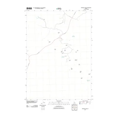
2010 Map of Inferno Cone
USGS Topo · Published 2010About this map
Volcanic formations dominate this 2010 survey of the Craters-of-the-Moon-Natl-Monum in Butte County. The landscape is a complex of cinder cones and craters, including Inferno Cone, Paisley Cone, and Snow Cone, which line the Loop Rd through the monument. This high-altitude desert environment is defined by its scarcity of water, marked by vital points such as Doves Waterholes, Big Sink Waterhole, and Yellowjacket Waterhole. To the north, the terrain transitions toward the slopes of Blizzard Mt Rd near the Martin Mine. Notable geological and archaeological landmarks like the Indian Tunnel, Crystal Pit, and Tepee Circles are documented here, alongside expansive lava features such as Broken Top and Trench Mortar Flat. The mapping reveals a harsh but structured landscape where early mining interests at the Little Cottonwood Creek headwaters met the geological preservation of the volcanic rift.
Find a feature on this map
26 named features on this map. Tap any name to fly to it.
Don’t see what you’re looking for? This feature index may not catch every label — zoom into the map to look around manually.
Map Details
Editions of this 2010 Inferno Cone Map
This is the sole edition of this map. No revisions or reprints were ever made.
Other maps of this area

1935 · MacKay
USGS Topo · 1:96,000

1955 · Idaho Falls
USGS Topo · 1:250,000

1958 · Idaho Falls
USGS Topo · 1:250,000

1960 · Grouse
USGS Topo · 1:62,500

1972 · North Laidlaw Butte
USGS Topo · 1:24,000

1972 · Little Park
USGS Topo · 1:24,000

1972 · Nichols Reservoir
USGS Topo · 1:24,000

1972 · Inferno Cone
USGS Topo · 1:24,000

1972 · Blizzard Mtn South
USGS Topo · 1:24,000
1973 · Fissure Butte
USGS Topo · 1:24,000