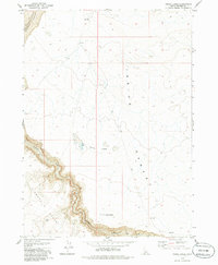
1979 Map of Inside Lakes
USGS Topo · Published 1986About this map
Bruneau Canyon and the winding course of the Jarbidge River dominate the southwestern corner of this Idaho high desert landscape. The terrain transitions from the deep incisions of the river system into the expansive, arid stretches of the Inside Desert and Diamond Desert. Based on 1970s fieldwork, the map documents a sparse, open territory where water is a critical but rare landmark, most notably found at the Inside Lakes. Transport across this portion of Owyhee County is limited to a primitive network of a Jeep Trail and an older Pack Trail, reflecting the isolation and specialized land use of the region during this era. Surveyed before modern developments, the sheet captures the raw topography of the canyonlands and the intermittent drainages like Poison Creek that define the local hydrology.
Find a feature on this map
8 named features on this map. Tap any name to fly to it.
Don’t see what you’re looking for? This feature index may not catch every label — zoom into the map to look around manually.
Map Details
Editions of this 1979 Inside Lakes Map
This is the sole edition of this map. No revisions or reprints were ever made.
Other maps of this area

1955 · Twin Falls
USGS Topo · 1:250,000

1958 · Twin Falls
USGS Topo · 1:250,000

1978 · The Arch
USGS Topo · 1:24,000

1979 · Stiff Tree Draw
USGS Topo · 1:24,000

1979 · Indian Hot Springs
USGS Topo · 1:24,000
1979 · Triguero Lake
USGS Topo · 1:24,000

1979 · Clover Butte South
USGS Topo · 1:24,000
1979 · Poison Butte
USGS Topo · 1:24,000

1979 · Cave Draw
USGS Topo · 1:24,000

1980 · Clover Butte North
USGS Topo · 1:24,000