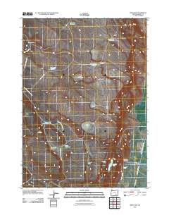
2011 Map of Irish Lake
USGS Topo · Published 2011About this map
Irish Lake and the surrounding high desert of Harney County are defined by a sophisticated system of water management in a region where every drop is counted. At the turn of the 21st century, the landscape is dotted with essential ranching infrastructure like Company Trough and Bailey Waterhole, alongside larger storage features such as Bed Ground Reservoir and Horse Creek Reservoir. The presence of the M S Davies Ranch underscores the area's continued use for livestock, while the Warm Springs Canal and the Donner und Blitzen River provide the primary hydraulic backbone for the eastern portion of the quadrangle. Geographic curiosities like Hole in the Ground and the steep terrain of Hoghouse Canyon break the desert expanse, offering landmarks for those navigating the network of primitive routes like Jack Mountain Rd and Center Patrol Rd.
Find a feature on this map
27 named features on this map. Tap any name to fly to it.
Don’t see what you’re looking for? This feature index may not catch every label — zoom into the map to look around manually.
Map Details
Editions of this 2011 Irish Lake Map
This is the sole edition of this map. No revisions or reprints were ever made.
Other maps of this area

1955 · Burns
USGS Topo · 1:250,000

1955 · Adel
USGS Topo · 1:250,000

1957 · Adel
USGS Topo · 1:250,000

1958 · Burns
USGS Topo · 1:250,000

1958 · Adel
USGS Topo · 1:250,000

1959 · Burns
USGS Topo · 1:250,000

1962 · Adel
USGS Topo · 1:250,000
1967 · Krumbo Reservoir
USGS Topo · 1:24,000
1967 · Jackass Butte
USGS Topo · 1:24,000
1967 · Frenchglen
USGS Topo · 1:24,000