
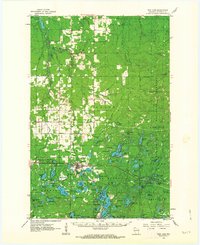
1961 Map of Iron Lake SW
USGS Topo · Published 1961About this map
Iron River serves as the primary hub of this northern Wisconsin landscape, situated along the Northern Pacific railroad corridor. The area is defined by an incredibly high density of glacial lakes, with Iron Lake, Lake Ruth, and Spider Lake among the dozens of named water bodies. This 1960s-era geography shows a region heavily transitioned toward recreation and conservation within the forest service boundaries, indicated by the numerous Boat Access points and the Campground near Moon Lake.
Find a feature on this map
55 named features on this map. Tap any name to fly to it.
Don’t see what you’re looking for? This feature index may not catch every label — zoom into the map to look around manually.
Map Details
Editions of this 1961 Iron Lake SW Map
This is the sole edition of this map. No revisions or reprints were ever made.
Other maps of this area

1943 · Iron Lake
USGS Topo · 1:48,000

1944 · Drummond
USGS Topo · 1:48,000

1945 · Highland
USGS Topo · 1:48,000

1947 · Drummond
USGS Topo · 1:48,000

1947 · Brule
USGS Topo · 1:48,000

1947 · Iron Lake
USGS Topo · 1:48,000

1949 · Highland
USGS Topo · 1:48,000

1953 · Ashland
USGS Topo · 1:250,000

1958 · Ashland
USGS Topo · 1:250,000
1961 · Iron Lake
USGS Topo · 1:62,500