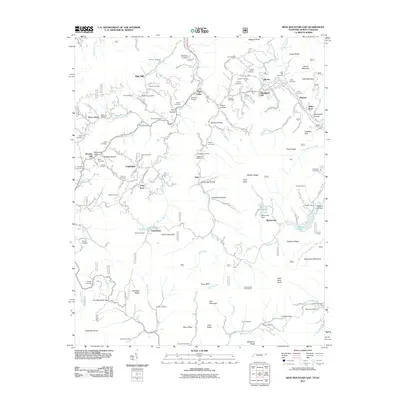
2011 Map of Iron Mountain Gap
USGS Topo · Published 2011About this map
Iron Mountain Gap serves as a primary geographic anchor for this Tennessee-North Carolina borderland, where the terrain transitions between high ridges and deep-cut hollows. The settlement pattern is defined by small communities like Tiger Valley, Oak Hill, and Tolley Town that follow the winding paths of Tiger Creek and Simery Creek. This landscape is heavily marked by family history, evidenced by dozens of namesake burial grounds including the Honeycutt Cemetery, Largent Cemetery, and Holly Hill Cemetery. The mapping of the Iron Mountain range includes specific infrastructure such as the Miller Lake Dam and the Clyde Smith Trail Shelter, reflecting a mix of local agriculture and mountain recreation. The network of roads, such as Sally Cove Creek Rd and Hughes Gap Rd, illustrates how transportation routes remained constrained by the steep topography of Laurel Mountain and Chestnut Ridge.
Find a feature on this map
151 named features on this map. Tap any name to fly to it.
Don’t see what you’re looking for? This feature index may not catch every label — zoom into the map to look around manually.
Map Details
Editions of this 2011 Iron Mountain Gap Map
This is the sole edition of this map. No revisions or reprints were ever made.
Other maps of this area

1891 · Roan Mountain
USGS Topo · 1:125,000

1894 · Roan Mountain
USGS Topo · 1:125,000

1904 · Roan Mountain
USGS Topo · 1:125,000

1934 · White Rocks Mtn
USGS Topo · 1:24,000

1934 · Bakersville
USGS Topo · 1:24,000

1934 · Iron Mtn Gap
USGS Topo · 1:24,000
1934 · Carvers Gap
USGS Topo · 1:24,000

1935 · Watauga Valley
USGS Topo · 1:48,000

1935 · Huntdale
USGS Topo · 1:24,000

1935 · Elizabethton
USGS Topo · 1:24,000