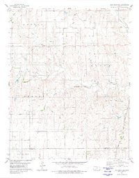
1980 Map of Iron Mountain
USGS Topo · Published 1980About this map
Iron Mountain rises above a landscape defined by the intersection of early frontier divisions and modern energy extraction. The Old Indian Treaty Boundary cuts across the northern terrain, marking a significant historical line that predates the modern county divisions of Kiowa and Comanche Counties. This 1980 survey captures the region's industrial character, heavily marked by the Reeder Gas Field and a dense network of gas wells, oil wells, and exploratory drill holes. The convergence of the Medicine Lodge River with its North Branch and South Branch provides the primary drainage for this area, while the Atchison Topeka and Santa Fe railroad follows the course of Otter Creek in the southeast, linking the remote energy fields to wider commerce.
Find a feature on this map
19 named features on this map. Tap any name to fly to it.
Don’t see what you’re looking for? This feature index may not catch every label — zoom into the map to look around manually.
Map Details
Editions of this 1980 Iron Mountain Map
This is the sole edition of this map. No revisions or reprints were ever made.
Other maps of this area

1889 · Kinsley
USGS Topo · 1:125,000

1892 · Kinsley
USGS Topo · 1:125,000

1892 · Coldwater
USGS Topo · 1:125,000

1894 · Kinsley
USGS Topo · 1:125,000

1955 · Pratt
USGS Topo · 1:250,000

1959 · Pratt
USGS Topo · 1:250,000

1968 · Wilmore SE
USGS Topo · 1:24,000

1968 · Belvidere
USGS Topo · 1:24,000

1968 · Haviland
USGS Topo · 1:24,000

1968 · Brenham
USGS Topo · 1:24,000