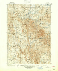
1908 Map of Ironside Mountain
USGS Topo · Published 1947About this map
Unity and Hereford anchor the northern reaches of this high-country landscape, where the Burnt River and its various forks dictate the pattern of early settlement. Surveyed at the dawn of the 1900s, the map reveals a remote ranching and timber economy centered on family-held landmarks and natural resource extraction. Industrial and agricultural development is evidenced by Otts Sawmill and the significant engineering of the Eldorado Ditch, which traverses the slopes of Mine Ridge.
Find a feature on this map
75 named features on this map. Tap any name to fly to it.
Don’t see what you’re looking for? This feature index may not catch every label — zoom into the map to look around manually.
Map Details
Editions of this 1908 Ironside Mountain Map
2 editions found
Other maps of this area

1901 · Baker City
USGS Topo · 1:125,000

1901 · Sumpter
USGS Topo · 1:125,000

1908 · Ironside Mountain
USGS Topo · 1:125,000
1951 · Bates
USGS Topo · 1:62,500

1955 · Baker
USGS Topo · 1:250,000

1955 · Burns
USGS Topo · 1:250,000

1955 · Canyon City
USGS Topo · 1:250,000

1955 · Boise
USGS Topo · 1:250,000

1958 · Burns
USGS Topo · 1:250,000

1958 · Boise
USGS Topo · 1:250,000