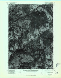
1975 Map of Island Falls NW
USGS Topo · Published 1980About this map
Rockabema Lake and the surrounding wilderness of Aroostook County dominate this orthophotoquad, which uses aerial photography from October 1975 to provide a literal view of the Maine woods. Unlike traditional topographic maps, this imagery reveals the actual density of the forest canopy and the precise shoreline of Pleasant Lake as they appeared in the mid-1970s. The terrain is marked by distinct summits like Green Mtn and Pickett Mtn, the latter of which overlooks Pickett Mtn Pond. The lack of road networks or human settlements printed on this sheet emphasizes the secluded, timber-heavy character of this northern landscape. This record captures the precise state of the timberland and hydrology before modern reforestation cycles or development altered the visible textures of the terrain.
Find a feature on this map
5 named features on this map. Tap any name to fly to it.
Don’t see what you’re looking for? This feature index may not catch every label — zoom into the map to look around manually.
Map Details
Editions of this 1975 Island Falls NW Map
This is the sole edition of this map. No revisions or reprints were ever made.
Other maps of this area

1940 · Island Falls
USGS Topo · 1:62,500

1940 · Oxbow
USGS Topo · 1:62,500

1942 · Island Falls
USGS Topo · 1:62,500

1942 · Oxbow
USGS Topo · 1:62,500

1954 · Shin Pond
USGS Topo · 1:62,500

1954 · Grand Lake Seboeis
USGS Topo · 1:62,500

1954 · Presque Isle
USGS Topo · 1:250,000

1958 · Presque Isle
USGS Topo · 1:250,000

1960 · Presque Isle
USGS Topo · 1:250,000
1965 · Oxbow
USGS Topo · 1:62,500