1983 Map of Island Of Rota (Luta)
USGS Topo · Published 1983About this map
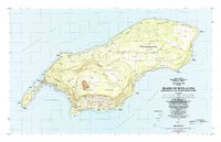
Songsong anchors the western peninsula of the island, situated on the narrow isthmus between the Sasanlagu and Sasanhaya bays. This 1983 survey by the United States Geological Survey and the Trust Territory of the Pacific Islands reveals a landscape defined by traditional cultural sites and modern development. Numerous Latte Stone locations and a Latte Stone Quarry near Mochong signify the deep indigenous history of the Chamorro people. The interior plateau of the Sabana rises above coastal settlements like Liyo and Sinapalu, with a Mine and various Borrow Pits indicating local extraction activities. From the Rota Airport in the north to the southern cliffs near Puntan Poña, the map detail captures a transition period for the island's infrastructure, noting Water Tanks, localized Ruins, and scattered Grave sites that provide essential data for genealogists and Pacific historians.
Find a feature on this map
106 named features on this map. Tap any name to fly to it.
Don’t see what you’re looking for? This feature index may not catch every label — zoom into the map to look around manually.
Map Details
Editions of this 1983 Island Of Rota (Luta) Map
This is the sole edition of this map. No revisions or reprints were ever made.
Other maps of this area
Featured Places
- Sabana, Rota Municipality
- Dugi, Rota Municipality
- Tachok (Teneto), Songsong
- Rota Resort, Rota Municipality
- Songsong, Rota Municipality