Loading...
Loading map...1999 Map of Island Of Rota (Luta)
USGS Topo · Published 2001About this map
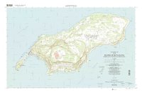
Songsong village occupies the narrow southwestern peninsula of Rota, positioned between the waters of Sasanlagu and Sasanhaya Bay. This 1999 survey, based on data updated from earlier 1968 and 1980 records, captures the island's landscape before the turn of the millennium. The terrain is dominated by the high plateau of the Mount Sabana Conservation Area and the iconic profile of Mount Taipingot (Wedding Cake Mountain) at the island's southern tip.
Find a feature on this map
86 named features on this map. Tap any name to fly to it.
Don’t see what you’re looking for? This feature index may not catch every label — zoom into the map to look around manually.
Map Details
Date Portrayed1999
Date Published2001
PublisherU.S. Geological Survey
Map TypeTopographic
Scale1:25,000
Physical Dimensions36.01 x 24.04 inches
Editions of this 1999 Island Of Rota (Luta) Map
This is the sole edition of this map. No revisions or reprints were ever made.
Other maps of this area
Featured Places
- Sabana, Rota Municipality
- Dugi, Rota Municipality
- Tachok (Teneto), Songsong
- Rota Resort, Rota Municipality
- Songsong, Rota Municipality
Source Details
SourceU.S. Geological Survey
CopyrightPublic Domain