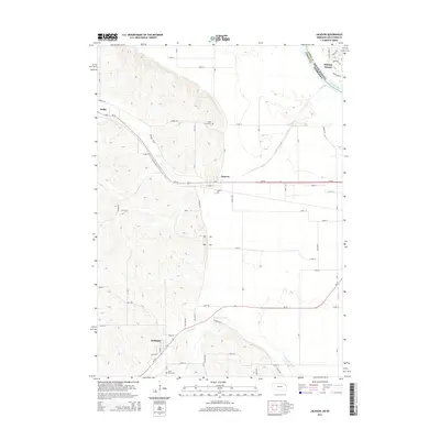
2014 Map of Jackson
USGS Topo · Published 2014About this map
Jackson and Hubbard sit along the transitional landscape where the Missouri River floodplain meets the elevated bluffs of northeast Nebraska. This 2014 survey captures the interface between modern development at Dakota Dunes and the rural agricultural tracts defined by the Pigeon Cr Ditch and Elk Creek. The topography is sharply divided between the level bottoms near the Missouri River and the undulating hills to the west, where Saint Johns Cem and Saint Marys Cem provide important geographic points for genealogical research. The transportation network is anchored by Us-20 and Ne-35, which link these small settlements. The map illustrates how drainage features like Jones Cr and Pigeon Cr have been managed to support the region's farming heritage, while the presence of the Union Co and Dakota Co boundary near the river highlights the jurisdictional complexity of this tri-state border region.
Find a feature on this map
57 named features on this map. Tap any name to fly to it.
Don’t see what you’re looking for? This feature index may not catch every label — zoom into the map to look around manually.
Map Details
Editions of this 2014 Jackson Map
This is the sole edition of this map. No revisions or reprints were ever made.
Other maps of this area

1898 · Elk Point
USGS Topo · 1:125,000

1901 · Elk Point
USGS Topo · 1:125,000

1907 · Elk Point
USGS Topo · 1:125,000

1955 · Sioux City
USGS Topo · 1:250,000

1958 · Sioux City
USGS Topo · 1:250,000

1959 · Sioux City
USGS Topo · 1:250,000

1963 · Sioux City South
USGS Topo · 1:24,000

1963 · Sioux City North
USGS Topo · 1:24,000

1963 · Jefferson
USGS Topo · 1:24,000
1964 · Ponca
USGS Topo · 1:24,000