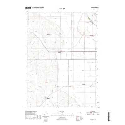
2017 Map of Jackson
USGS Topo · Published 2017About this map
Jackson and Hubbard sit along the rolling landscape of the Nebraska and South Dakota borderlands, where the transition from loess hills to the flat Missouri River floodplain defines the local character. This survey highlights the intricate drainage systems necessary for the region's agricultural productivity, notably the Pigeon Cr Ditch and the winding course of Elk Cr. The map provides significant detail for family historians, marking the Saint Johns Cem near Willis and Saint Marys Cem further south. The convergence of numerous named thoroughfares, such as Monona Blvd and Knox Blvd, underscores a developed network of rural roads that linked these farm communities. Modern recreational additions are also visible on the South Dakota side of the border, where the Bluestem Trl and Firethorn Trl weave through the landscape near the Missouri River's northern bank.
Find a feature on this map
44 named features on this map. Tap any name to fly to it.
Don’t see what you’re looking for? This feature index may not catch every label — zoom into the map to look around manually.
Map Details
Editions of this 2017 Jackson Map
This is the sole edition of this map. No revisions or reprints were ever made.
Other maps of this area

1898 · Elk Point
USGS Topo · 1:125,000

1901 · Elk Point
USGS Topo · 1:125,000

1907 · Elk Point
USGS Topo · 1:125,000

1955 · Sioux City
USGS Topo · 1:250,000

1958 · Sioux City
USGS Topo · 1:250,000

1959 · Sioux City
USGS Topo · 1:250,000

1963 · Sioux City South
USGS Topo · 1:24,000

1963 · Sioux City North
USGS Topo · 1:24,000

1963 · Jefferson
USGS Topo · 1:24,000
1964 · Ponca
USGS Topo · 1:24,000