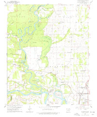
1962 Map of Jacksonport
USGS Topo · Published 1977About this map
Jacksonport sits at the historic confluence of the White River and the Black River in the early 1960s, a landscape defined by the shifting meanders of the river delta. The terrain is marked by numerous oxbows and backwaters like Horseshoe Lake, Dead Mule Bend, and Goose Pond, illustrating a river system that has frequently redrawn the boundaries between Independence and Jackson counties. This survey preserves a detailed view of rural life through its numerous named cemeteries and country churches, such as Elgin Landmark Ch and Hickory Grove Ch. The presence of Point Ferry on the White River and the Missouri Pacific railroad through Campbell Station and Diaz highlights the dual reliance on water and rail transportation that shaped these delta communities before modern highway expansion dominated the region.
Find a feature on this map
75 named features on this map. Tap any name to fly to it.
Don’t see what you’re looking for? This feature index may not catch every label — zoom into the map to look around manually.
Map Details
Editions of this 1962 Jacksonport Map
3 editions found

Other maps of this area

1932 · Strawberry
USGS Topo · 1:62,500

1935 · Alicia
USGS Topo · 1:62,500

1935 · Strawberry
USGS Topo · 1:62,500

1935 · Newport
USGS Topo · 1:62,500

1935 · Tuckerman
USGS Topo · 1:62,500

1941 · Strawberry
USGS Topo · 1:62,500

1953 · Memphis
USGS Topo · 1:250,000

1954 · Charlotte
USGS Topo · 1:24,000

1955 · Cord
USGS Topo · 1:24,000

1956 · Memphis
USGS Topo · 1:250,000