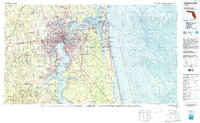
1980 Map of Jacksonville
USGS Topo · Published 1984About this map
The St Johns River anchors this 1980 study, carving through the heart of Jacksonville and widening into Doctors Lake as it flows south toward Orange Park and Green Cove Springs. This map captures a significant military and maritime landscape, detailing the expansive Cecil Field Naval Air Station and the Jacksonville Naval Air Station, while the Intracoastal Waterway snakes behind the barrier islands of Jacksonville Beach and Neptune Beach. Cultural and historical landmarks like the Kingsley Plantation State Historic Site on Fort George Island and the Fort Caroline National Memorial are clearly marked. To the west, the landscape shifts toward the timberlands of Cary State Forest and the training grounds of Camp Blanding (National Guard), while the northern reaches show the complex wetlands surrounding Black Hammock Island and Nassau Sound.
Find a feature on this map
81 named features on this map. Tap any name to fly to it.
Don’t see what you’re looking for? This feature index may not catch every label — zoom into the map to look around manually.
Map Details
Editions of this 1980 Jacksonville Map
This is the sole edition of this map. No revisions or reprints were ever made.
Other maps of this area

1917 · Orange Park
USGS Topo · 1:62,500

1917 · Cambon
USGS Topo · 1:62,500

1917 · Macclenny
USGS Topo · 1:62,500

1917 · Hilliard
USGS Topo · 1:62,500

1918 · St Marys
USGS Topo · 1:62,500

1918 · Middleburg
USGS Topo · 1:62,500

1918 · Moniac
USGS Topo · 1:62,500

1918 · Lawtey
USGS Topo · 1:62,500

1918 · Cambon
USGS Topo · 1:62,500

1918 · Jacksonville
USGS Topo · 1:62,500