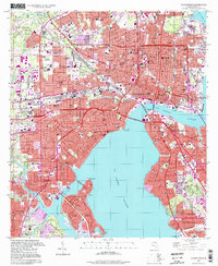
1994 Map of Jacksonville
USGS Topo · Published 1998About this map
The St Johns River and Ortega River define the layout of this urban landscape, where mid-century infrastructure meets long-established residential neighborhoods. The survey highlights a period of intense industrial and transit development, centering on the Union Station rail hub and the expansive Municipal Terminals along the waterfront near Tallyrand. Large institutional grounds like Evergreen Cemetery and the many schools, such as Northwestern High Sch and Lee High Sch, reveal the city's social fabric.
Find a feature on this map
163 named features on this map. Tap any name to fly to it.
Don’t see what you’re looking for? This feature index may not catch every label — zoom into the map to look around manually.
Map Details
Editions of this 1994 Jacksonville Map
This is the sole edition of this map. No revisions or reprints were ever made.
Other maps of this area

1917 · Orange Park
USGS Topo · 1:62,500

1917 · Cambon
USGS Topo · 1:62,500

1918 · Middleburg
USGS Topo · 1:62,500

1918 · Cambon
USGS Topo · 1:62,500

1918 · Jacksonville
USGS Topo · 1:62,500

1918 · Orange Park
USGS Topo · 1:62,500

1941 · Middleburg
USGS Topo · 1:62,500

1948 · Jacksonville
USGS Topo · 1:250,000

1948 · Eastport
USGS Topo · 1:24,000

1949 · Jacksonville Heights
USGS Topo · 1:24,000
Featured Places
- Jacksonville, FL
- Lake Shore, Jacksonville
- Pearl Court, Jacksonville
- Saint Nicholas, Jacksonville
- Larsen, Jacksonville