
1941 Map of Middleburg
USGS Topo · Published 1943About this map
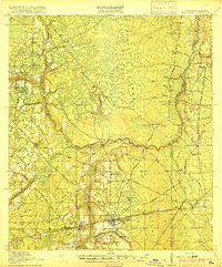
Middleburg serves as a central hub at the confluence of the North Fork Black Creek and its southern tributaries, revealing a landscape defined by water and woods in North Florida. The settlement patterns of Clay County are clearly visible through a dense network of local landmarks, including the Rideout Ferry crossing the main channel of Black Creek. The interior is dotted with numerous small educational and religious sites such as Hatcherville School, Duckpond School, and Black Creek Church, reflecting the rural social structure of the early twentieth century. Transportation is anchored by the Atlantic Coast Line railroad and a series of named crossings like Dowling Bridge and Bristol Bridge. Topographical features like Federal Hill and the Clay Hill rise above the many creek branches, while the eastern edge is defined by the broad reach of Doctors Lake and Doctors Inlet.
Find a feature on this map
58 named features on this map. Tap any name to fly to it.
Don’t see what you’re looking for? This feature index may not catch every label — zoom into the map to look around manually.
Map Details
Editions of this 1941 Middleburg Map
This is the sole edition of this map. No revisions or reprints were ever made.
Other maps of this area

1917 · Orange Park
USGS Topo · 1:62,500

1917 · Cambon
USGS Topo · 1:62,500

1917 · Macclenny
USGS Topo · 1:62,500

1918 · Middleburg
USGS Topo · 1:62,500

1918 · Lawtey
USGS Topo · 1:62,500

1918 · Cambon
USGS Topo · 1:62,500

1918 · Jacksonville
USGS Topo · 1:62,500

1918 · Orange Park
USGS Topo · 1:62,500
1918 · Macclenny
USGS Topo · 1:62,500

1941 · Starke
USGS Topo · 1:62,500