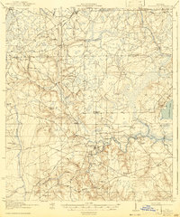
1918 Map of Middleburg
USGS Topo · Published 1943About this map
Middleburg sits at the strategic junction of the North and South Forks of Black Creek, serving as a focal point for this early 20th-century Clay County landscape. The area is defined by its intricate water network, where numerous branches like Sal Taylor Creek and Yellow Water Creek feed into the larger creek systems that eventually reach Doctors Lake. Transportation in this era relied heavily on river crossings and established wagon roads, evidenced by the presence of Rideout Ferry and Ross Ferry, along with landmarks like Bristol Bridge.
Find a feature on this map
55 named features on this map. Tap any name to fly to it.
Don’t see what you’re looking for? This feature index may not catch every label — zoom into the map to look around manually.
Map Details
Editions of this 1918 Middleburg Map
4 editions found
Other maps of this area

1917 · Orange Park
USGS Topo · 1:62,500

1917 · Cambon
USGS Topo · 1:62,500

1917 · Macclenny
USGS Topo · 1:62,500

1918 · Middleburg
USGS Topo · 1:62,500

1918 · Lawtey
USGS Topo · 1:62,500

1918 · Cambon
USGS Topo · 1:62,500

1918 · Jacksonville
USGS Topo · 1:62,500

1918 · Orange Park
USGS Topo · 1:62,500

1918 · Macclenny
USGS Topo · 1:62,500

1941 · Starke
USGS Topo · 1:62,500