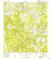
1949 Map of Middleburg
USGS Topo · Published 1955About this map
Middleburg serves as the focal point of this Clay County landscape, positioned at the confluence of the North Fork Black Creek and South Fork Black Creek. The area reflects a post-war transition, where traditional river-based landmarks like Rideout Ferry and established communities such as Doctors Inlet and Russell coexist with expanding military and aviation infrastructure. The northern portion of the map is dominated by the Cecil Naval Auxiliary Air Station, while smaller facilities like Branan Outlying Airfield and the Middleburg Airport dot the surrounding pine lands.
Find a feature on this map
50 named features on this map. Tap any name to fly to it.
Don’t see what you’re looking for? This feature index may not catch every label — zoom into the map to look around manually.
Map Details
Editions of this 1949 Middleburg Map
This is the sole edition of this map. No revisions or reprints were ever made.
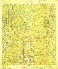
Other maps of this area

1917 · Orange Park
USGS Topo · 1:62,500

1917 · Cambon
USGS Topo · 1:62,500

1917 · Macclenny
USGS Topo · 1:62,500

1918 · Middleburg
USGS Topo · 1:62,500

1918 · Lawtey
USGS Topo · 1:62,500

1918 · Cambon
USGS Topo · 1:62,500

1918 · Jacksonville
USGS Topo · 1:62,500

1918 · Orange Park
USGS Topo · 1:62,500
1918 · Macclenny
USGS Topo · 1:62,500

1941 · Starke
USGS Topo · 1:62,500