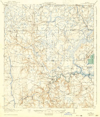
1918 Map of Middleburg
USGS Topo · Published 1941About this map
Middleburg serves as the focal point of this 1917 survey of Clay County, situated at the confluence where Black Creek branches into its north and south forks. The landscape is defined by an intricate network of waterways and early transport crossings, including Rideout Ferry, Moss Ferry, and Dowling Bridge. These routes connected isolated rural communities and a dense system of country schools such as Garden City School, Hatcherville School, and Russell School.
Find a feature on this map
60 named features on this map. Tap any name to fly to it.
Don’t see what you’re looking for? This feature index may not catch every label — zoom into the map to look around manually.
Map Details
Editions of this 1918 Middleburg Map
4 editions found
Other maps of this area

1917 · Orange Park
USGS Topo · 1:62,500

1917 · Cambon
USGS Topo · 1:62,500

1917 · Macclenny
USGS Topo · 1:62,500

1918 · Middleburg
USGS Topo · 1:62,500

1918 · Lawtey
USGS Topo · 1:62,500

1918 · Cambon
USGS Topo · 1:62,500

1918 · Jacksonville
USGS Topo · 1:62,500

1918 · Orange Park
USGS Topo · 1:62,500

1918 · Macclenny
USGS Topo · 1:62,500

1941 · Starke
USGS Topo · 1:62,500