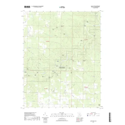
2017 Map of Jam Up Cave
USGS Topo · Published 2017About this map
The Ozark National Scenic Riverway protects the winding path of the Jacks Fork as it carves through Shannon County, defined by prominent river features like Bee Bluff, Chalk Bluff, and Red Bluff. This landscape is characterized by a dense network of hollows, including Stillhouse Hollow, Dark Hollow, and Fly Blow Hollow, which feed into the primary waterways. Settlement patterns follow the higher ground and ridge lines, such as Jenny Ridge and Angel Ridge, while agricultural and domestic life is anchored by family and community sites like Turkey Oak Cem and Duncan Cem. To the south, the periphery of Birch Tree connects to the rural road network, including State Hwy ZZ and State Hwy M. Smaller tributaries like Jam Up Cr and Leatherwood Cr create a complex drainage system through the karst topography of the Missouri Ozarks.
Find a feature on this map
80 named features on this map. Tap any name to fly to it.
Don’t see what you’re looking for? This feature index may not catch every label — zoom into the map to look around manually.
Map Details
Editions of this 2017 Jam Up Cave Map
This is the sole edition of this map. No revisions or reprints were ever made.
Other maps of this area

1915 · Eminence
USGS Topo · 1:62,500

1917 · Eminence
USGS Topo · 1:62,500

1931 · Bandyville
USGS Topo · 1:48,000

1944 · Birch Tree
USGS Topo · 1:62,500

1945 · Montier
USGS Topo · 1:62,500

1946 · Summersville
USGS Topo · 1:62,500

1948 · Montier
USGS Topo · 1:62,500

1948 · Birch Tree
USGS Topo · 1:62,500

1948 · Summersville
USGS Topo · 1:62,500

1949 · Rolla
USGS Topo · 1:250,000