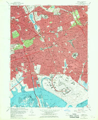
1966 Map of Jamaica
USGS Topo · Published 1969About this map
The John F Kennedy International Airport dominates the southern landscape of this mid-1960s survey, marking a period of massive aviation expansion alongside the tidal flats of Jamaica Bay. The map documents a densely developed urban corridor where established residential neighborhoods like Forest Hills, Kew Gardens, and Richmond Hill are interwoven with an intensive network of post-war infrastructure. The Van Wyck Expressway and Belt Parkway serve as primary arteries, slicing through the older street grids and connecting the airport to the interior of Queens.
Find a feature on this map
166 named features on this map. Tap any name to fly to it.
Don’t see what you’re looking for? This feature index may not catch every label — zoom into the map to look around manually.
Map Details
Editions of this 1966 Jamaica Map
2 editions found
Other maps of this area

1889 · Brooklyn
USGS Topo · 1:62,500

1891 · Brooklyn
USGS Topo · 1:62,500

1891 · Harlem
USGS Topo · 1:62,500

1897 · Harlem
USGS Topo · 1:62,500

1897 · Brooklyn
USGS Topo · 1:62,500

1897 · Hempstead
USGS Topo · 1:62,500

1897 · Oyster Bay
USGS Topo · 1:62,500

1898 · Harlem
USGS Topo · 1:62,500

1898 · Hempstead
USGS Topo · 1:62,500

1898 · Brooklyn
USGS Topo · 1:62,500