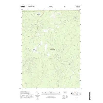
2019 Map of James City
USGS Topo · Published 2019About this map
The Allegheny National Forest dominates this section of Elk County, where the high plateau is etched by a dense network of drainages like Big Mill Cr and Pigeon Run. Small settlements such as James City, McKinley, and Carlson are situated along the ridgeline roads, reflecting a landscape defined by both timber history and modern recreation. The presence of Highland Cem near Highland Corners serves as a primary point of interest for genealogists tracing local families in Highland Township. A complex system of multi-use trails, including the Twin Lakes Hiking paths and the Timberline ATV A Loop, underscores the area's transition from industrial forestry to a destination for outdoor enthusiasts. The topography reveals significant relief around Bush Hollow, where seasonal routes like Brush Hollow Hiking (Snow) navigate the steep terrain.
Find a feature on this map
38 named features on this map. Tap any name to fly to it.
Don’t see what you’re looking for? This feature index may not catch every label — zoom into the map to look around manually.
Map Details
Editions of this 2019 James City Map
This is the sole edition of this map. No revisions or reprints were ever made.
Other maps of this area

1934 · Kane
USGS Topo · 1:48,000

1935 · Mt. Jewett
USGS Topo · 1:48,000

1939 · Kane
USGS Topo · 1:62,500

1940 · Hallton
USGS Topo · 1:48,000

1940 · Mt. Jewett
USGS Topo · 1:62,500

1941 · Ridgway
USGS Topo · 1:62,500

1943 · Hallton
USGS Topo · 1:62,500

1944 · Ridgway
USGS Topo · 1:62,500

1957 · Warren
USGS Topo · 1:250,000

1958 · Warren
USGS Topo · 1:250,000
Featured Places
- Highland Corners, Highland Township
- James City, Highland Township
- McKinley, Highland Township
- Nansen, Highland Township
- Carlson, Highland Township