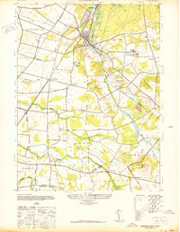
1942 Map of Jamesburg
USGS Topo · Published 1942About this map
Jamesburg and the neighboring industrial borough of Helmetta anchor this mid-century survey of the Middlesex County interior. The landscape is defined by the convergence of the Pennsylvania Railroad lines, which supported the local economy and connected outlying settlements like Applegarth and Hoffman Sta. Just east of the main town center, the Jamesburg State Reformatory occupies a significant tract, while the northern reaches show the manicured grounds of the Forsgate Country Club.
Find a feature on this map
36 named features on this map. Tap any name to fly to it.
Don’t see what you’re looking for? This feature index may not catch every label — zoom into the map to look around manually.
Map Details
Editions of this 1942 Jamesburg Map
This is the sole edition of this map. No revisions or reprints were ever made.
Other maps of this area

1888 · Bordentown
USGS Topo · 1:62,500

1888 · New Brunswick
USGS Topo · 1:62,500

1888 · Princeton
USGS Topo · 1:62,500

1888 · Cassville
USGS Topo · 1:62,500

1893 · Bordentown
USGS Topo · 1:62,500

1893 · New Brunswick
USGS Topo · 1:62,500

1894 · Princeton
USGS Topo · 1:62,500

1894 · Cassville
USGS Topo · 1:62,500

1900 · Cassville
USGS Topo · 1:62,500

1901 · New Brunswick
USGS Topo · 1:62,500
Featured Places
- Old Bridge Township, NJ
- Monroe Township, NJ
- East Brunswick Township, NJ
- South Brunswick, NJ
- Manalapan Township, NJ