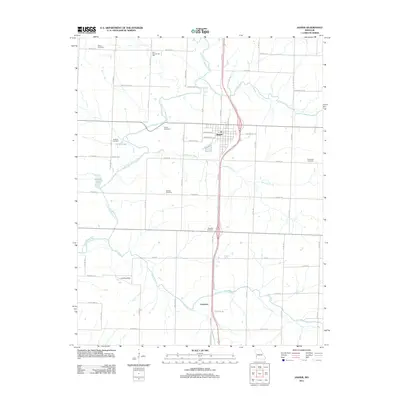
2011 Map of Jasper
USGS Topo · Published 2011About this map
Jasper and the surrounding farmland of Jasper County are defined by the convergence of several waterways, including the North Fork Spring River, Opossum Creek, and Cripple Creek. The landscape exhibits a traditional Midwestern grid of section roads like Sumac Rd and Redbud Rd, punctuated by a high density of burial sites that speak to the long-standing agricultural communities here. Family and community heritage is anchored by landmarks such as Waters Cemetery, Stafford Cemetery, and Hendricks Cemetery, as well as the Blue Community Hall to the northwest. To the south, the small settlement of Carytown sits near the winding path of Dry Fork, while the presence of a Landing Strip and named impoundments like Webbs Lake and Scroggs Lake illustrate the localized development of the rural terrain in the early 21st century.
Find a feature on this map
60 named features on this map. Tap any name to fly to it.
Don’t see what you’re looking for? This feature index may not catch every label — zoom into the map to look around manually.
Map Details
Editions of this 2011 Jasper Map
This is the sole edition of this map. No revisions or reprints were ever made.
Other maps of this area

1886 · Carthage
USGS Topo · 1:125,000

1894 · Carthage
USGS Topo · 1:125,000

1921 · Sarcoxie
USGS Topo · 1:62,500

1947 · Joplin
USGS Topo · 1:250,000

1949 · Joplin
USGS Topo · 1:250,000

1954 · Joplin
USGS Topo · 1:250,000

1958 · Joplin
USGS Topo · 1:250,000

1959 · Joplin
USGS Topo · 1:250,000
1962 · Kenoma
USGS Topo · 1:24,000
1962 · Jasper
USGS Topo · 1:24,000