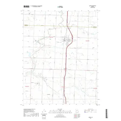
2017 Map of Jasper
USGS Topo · Published 2017About this map
Jasper serves as the central hub of this Missouri landscape, situated near the headwaters of the North Fork Spring River and Cripple Cr. The town's grid is detailed with street names like E Lexington Ave and Maiden Ln, while the surrounding countryside in both Jasper and Barton Counties is defined by a dense network of family-named cemeteries and rural landmarks. Local history is preserved in sites such as Stafford Cem and Ruddick Cem, which dot the agricultural sections alongside smaller settlements like Carytown. The hydrology of the region is equally prominent, featuring Scroggs Lake, Webbs Lake, and the winding paths of Opossum Cr and Dry Fork. This 2017 survey provides a high-resolution view of modern land use, showing how legacy farm boundaries and regional transit corridors like U.S. Route 71 have shaped the contemporary township structure.
Find a feature on this map
77 named features on this map. Tap any name to fly to it.
Don’t see what you’re looking for? This feature index may not catch every label — zoom into the map to look around manually.
Map Details
Editions of this 2017 Jasper Map
This is the sole edition of this map. No revisions or reprints were ever made.
Other maps of this area

1886 · Carthage
USGS Topo · 1:125,000

1894 · Carthage
USGS Topo · 1:125,000

1921 · Sarcoxie
USGS Topo · 1:62,500

1947 · Joplin
USGS Topo · 1:250,000

1949 · Joplin
USGS Topo · 1:250,000

1954 · Joplin
USGS Topo · 1:250,000

1958 · Joplin
USGS Topo · 1:250,000

1959 · Joplin
USGS Topo · 1:250,000
1962 · Kenoma
USGS Topo · 1:24,000
1962 · Jasper
USGS Topo · 1:24,000