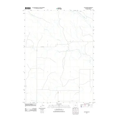
2012 Map of Jay Em NW
USGS Topo · Published 2012About this map
Red Cloud Cem stands as a quiet focal point in this high-plains landscape of eastern Wyoming, situated just north of Cord-14. The terrain is defined by a dendritic network of ephemeral drainages that shape the local ranching geography, including Cottonwood Cr and Muskrat Cr. A network of rural roads provides the primary infrastructure here, notably Fort Laramie Rd, which cuts across the central portion of the quadrangle. These routes connect isolated holdings and family landmarks across the Goshen County countryside. Toward the northeast, the winding path of Rawhide Cr meanders through the open territory, while the southern reaches are marked by the presence of Red Cloud Cr, illustrating the vital role of these seasonal water sources in a semi-arid environment.
Find a feature on this map
12 named features on this map. Tap any name to fly to it.
Don’t see what you’re looking for? This feature index may not catch every label — zoom into the map to look around manually.
Map Details
Editions of this 2012 Jay Em NW Map
This is the sole edition of this map. No revisions or reprints were ever made.
Other maps of this area

1896 · Patrick
USGS Topo · 1:125,000

1896 · Hartville
USGS Topo · 1:125,000

1901 · Hartville
USGS Topo · 1:125,000

1950 · Casebier Hill
USGS Topo · 1:24,000

1951 · Moore Spring
USGS Topo · 1:24,000

1954 · Torrington
USGS Topo · 1:250,000

1958 · Torrington
USGS Topo · 1:250,000
1974 · Jay Em NW
USGS Topo · 1:24,000

1974 · Jay Em
USGS Topo · 1:24,000

1974 · Rawhide Buttes East
USGS Topo · 1:24,000