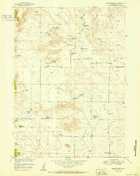
1951 Map of Moore Spring
USGS Topo · Published 1951About this map
High plains ranching life in Goshen County is meticulously documented here, showing a landscape defined by water and wide-ranging livestock operations. Scattered homesteads such as the Newell Ranch and Emma Ranch are connected by a network of unimproved dirt tracks like Crescent Basin Road and the Fort Laramie Road. The presence of the Moore Spring School and a small Cem near the Fred Damrow Ranch points to a once-active rural community hub centered around the dependable water of Moore Spring. Numerous windmills dot the terrain between the Wildcat Hills and Spring Hills, signifying the critical importance of groundwater for the various operations, including the Vandra Ranch and Blevin Ranch, in this arid landscape.
Find a feature on this map
32 named features on this map. Tap any name to fly to it.
Don’t see what you’re looking for? This feature index may not catch every label — zoom into the map to look around manually.
Map Details
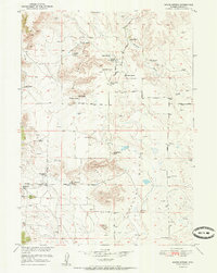
Editions of this 1951 Moore Spring Map
3 editions found
Historical Maps of Goshen County Through Time
89 maps found

1896 Patrick
Goshen County, WY

1899 Goshen Hole
Goshen County, WY

1950 Casebier Hill
Goshen County, WY

1950 Rockeagle
Goshen County, WY

1951 Moore Spring
Goshen County, WY

1960 Barnes
Goshen County, WY

1960 Cottier
Goshen County, WY

1960 Diamond Flat
Goshen County, WY

1960 Duroc
Goshen County, WY

1960 Habig Spring
Goshen County, WY

1960 Kessler Gap
Goshen County, WY

1960 Mc Compsey Pass
Goshen County, WY

1960 Needle Rock
Goshen County, WY

1960 Robb Draw
Goshen County, WY

1963 Carpenter Ranch
Goshen County, WY

1963 Cattail Ranch NE
Goshen County, WY

1963 Glomill Reservoir
Goshen County, WY

1963 Tea Kettle Rock
Goshen County, WY

1963 Torrington SE
Goshen County, WY

1963 Y B O Canyon
Goshen County, WY

1968 Glomill Reservoir
Goshen County, WY

1974 Jay Em
Goshen County, WY

1974 Jay Em NW
Goshen County, WY

1974 Rawhide Buttes East
Goshen County, WY

1974 Spoon Butte
Goshen County, WY

1974 Spoon Butte SW
Goshen County, WY

1977 Hileman Draw
Goshen County, WY

1977 Prairie Center
Goshen County, WY

1977 Red Cloud Creek East
Goshen County, WY

1977 Red Cloud Creek West
Goshen County, WY

1977 Spoon Butte NW
Goshen County, WY

1977 Van Tassell SE
Goshen County, WY

1978 Lone Sand Hill
Goshen County, WY

1978 Rawhide Buttes West
Goshen County, WY

1990 Barnes
Goshen County, WY

1990 Casebier Hill
Goshen County, WY

1990 Cattail Ranch NE
Goshen County, WY

1990 Cottier
Goshen County, WY

1990 Diamond Flat
Goshen County, WY

1990 Doty Hill
Goshen County, WY

1990 Duroc
Goshen County, WY

1990 Glomill Reservoir
Goshen County, WY

1990 Habig Spring
Goshen County, WY

1990 Jay Em
Goshen County, WY

1990 Jay Em NW
Goshen County, WY

1990 Kessler Gap
Goshen County, WY

1990 Lone Sand Hill
Goshen County, WY

1990 Mc Compsey Pass
Goshen County, WY

1990 Moore Spring
Goshen County, WY

1990 Needle Rock
Goshen County, WY

1990 Red Cloud Creek East
Goshen County, WY

1990 Red Cloud Creek West
Goshen County, WY

1990 Robb Draw
Goshen County, WY

1990 Spoon Butte
Goshen County, WY

1990 Spoon Butte NW
Goshen County, WY

1990 Spoon Butte SW
Goshen County, WY

1990 Tea Kettle Rock
Goshen County, WY

1990 Torrington SE
Goshen County, WY

1990 Y B O Canyon
Goshen County, WY

2021 Barnes
Goshen County, WY

2021 Casebier Hill
Goshen County, WY

2021 Cattail Ranch NE
Goshen County, WY

2021 Cottier
Goshen County, WY

2021 Diamond Flat
Goshen County, WY

2021 Doty Hill
Goshen County, WY

2021 Duroc
Goshen County, WY

2021 Glomill Reservoir
Goshen County, WY

2021 Habig Spring
Goshen County, WY

2021 Hileman Draw
Goshen County, WY

2021 Jay Em
Goshen County, WY

2021 Jay Em NW
Goshen County, WY

2021 Lone Sand Hill
Goshen County, WY

2021 McCompsey Pass
Goshen County, WY

2021 Moore Spring
Goshen County, WY

2021 Needle Rock
Goshen County, WY

2021 Prairie Center
Goshen County, WY

2021 Rawhide Buttes East
Goshen County, WY

2021 Rawhide Buttes West
Goshen County, WY

2021 Red Cloud Creek East
Goshen County, WY

2021 Red Cloud Creek West
Goshen County, WY

2021 Robb Draw
Goshen County, WY

2021 Spoon Butte
Goshen County, WY

2021 Spoon Butte NW
Goshen County, WY

2021 Spoon Butte SW
Goshen County, WY

2021 Tea Kettle Rock
Goshen County, WY

2021 Torrington SE
Goshen County, WY

2021 Van Tassell SE
Goshen County, WY

2021 Y B O Canyon
Goshen County, WY

2023 Kessler Gap
Goshen County, WY