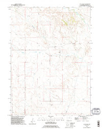
1990 Map of Jay Em NW
USGS Topo · Published 1995About this map
Red Cloud Cemetery sits within the undulating terrain of this Goshen County landscape, serving as a primary point of historical interest for genealogists and local historians. The area is defined by the ephemeral flow of Rawhide Creek, Cottonwood Creek, and Muskrat Creek, which carve through the high plains. This 1990s revision reflects a landscape largely dedicated to ranching and transport, notably marked by the Fort Laramie Road as it cuts east-to-west across the northern half of the quadrangle. The presence of a Landing Strip and multiple Pipeline corridors suggests the intersection of traditional land use with modern infrastructure and energy transit. Researchers can trace the path of historical travel routes against the natural drainage patterns that have shaped movement through this section of Wyoming for generations.
Find a feature on this map
8 named features on this map. Tap any name to fly to it.
Don’t see what you’re looking for? This feature index may not catch every label — zoom into the map to look around manually.
Map Details
Editions of this 1990 Jay Em NW Map
This is the sole edition of this map. No revisions or reprints were ever made.
Other maps of this area

1896 · Patrick
USGS Topo · 1:125,000

1896 · Hartville
USGS Topo · 1:125,000

1901 · Hartville
USGS Topo · 1:125,000

1950 · Casebier Hill
USGS Topo · 1:24,000

1951 · Moore Spring
USGS Topo · 1:24,000

1954 · Torrington
USGS Topo · 1:250,000

1958 · Torrington
USGS Topo · 1:250,000
1974 · Jay Em NW
USGS Topo · 1:24,000

1974 · Jay Em
USGS Topo · 1:24,000

1974 · Rawhide Buttes East
USGS Topo · 1:24,000